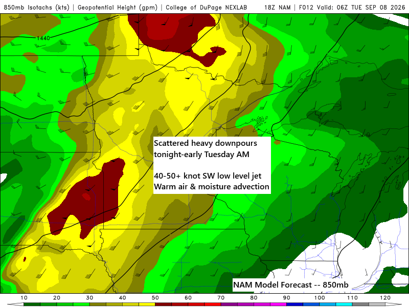
Expect another round of heavy downpours and scattered thunderstorms across northeast Minnesota and northwest Wisconsin tonight into early Tuesday morning.
For Duluth: Occasional showers and a few thunderstorms are expected tonight, with heavy downpours likely overnight into early Tuesday morning. The rain should clear between 6-8 AM Tuesday, leading to a muggy day with dew points around 65-70 degrees and a low chance of late afternoon showers or thunderstorms. Looking ahead, another round of scattered showers and thunderstorms may occur Friday night, with additional rain possible late in the weekend and into early next week. The late weekend/early next week system could be significant as a strong trough moves eastward from the Pacific Northwest.
…Tonight-Tuesday…
At the surface, a cold front will progress eastward from the northern Plains, moving through the Northland Tuesday afternoon and evening. The primary risk for showers, thunderstorms, and localized heavy rainfall will occur tonight ahead of the front within the warm, moisture-rich air mass. There remains a low-confidence potential for isolated showers or thunderstorms to redevelop along the cold front as it traverses the Northland Tuesday afternoon and evening.

Significant divergence has developed over the upper Midwest this afternoon between two streaks—one to the northeast and the other approaching from the southwest—creating strong lift that will help generate rain tonight.

A strengthening southwesterly low-level jet tonight will transport significant moisture, with precipitable water values between 1.75 and over 2 inches into the Northland, likely resulting in localized torrential downpours.

On average, much of northeast Minnesota and northwest Wisconsin is expected to receive around a quarter to half an inch of rain by mid-morning Tuesday, with some areas likely seeing heavier amounts of 1 to 2 inches.

If you’d like to support my work, please consider making a donation. Thank you for your generosity!
Make a one-time donation
Make a monthly donation
Make a yearly donation
Choose an amount
Or enter a custom amount
Your contribution is appreciated.
Your contribution is appreciated.
Your contribution is appreciated.
A powerful system is steadily advancing northeast across western-central Canada and the northern Plains today.
Goes-19 water vapor loop from Monday, September 7, 2026, ending at 5:40 PM CT.

…Gales possible on Lake Superior Wednesday…
Behind the system on Tuesday, west winds are expected to strengthen, bringing a chance of gale-force gusts of 35 to 50 mph over Lake Superior on Wednesday. With winds from the west, the highest waves will likely occur across the central and eastern parts of the lake.

A preliminary analysis suggests a potentially strong weather system developing late this weekend, advancing northeast from the northern Rockies and western High Plains. Rainfall is anticipated between Sunday and Monday.
Below is the European model 500mb forecast for 7 PM on Sunday, September 13, 2026.

Leave a Reply