Category: Uncategorized
-

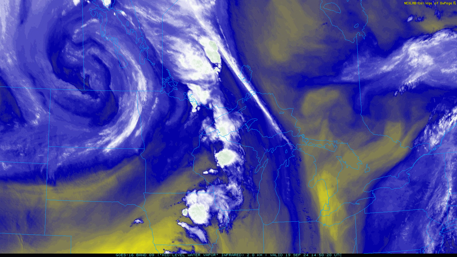
Scattered Showers Expected Tuesday
5:30 PM Monday, April 21, 2025 Updated precipitation totals for Duluth, Minnesota Month to date: 1.85 inches (+0.16 inches above normal) Since March 1st: 3.21 inches (+0.06 inches above normal) Since January 1st: 4.78 inches (-0.33 inches below normal) One trough has exited the Northland this afternoon, but a new…
-

Weather Update: 24-Hour Precipitation Totals for NE MN and NW WI
2:50 PM Monday, April 14, 2025 24-Hour Precipitation Reports ending 2 PM Monday, April 14, 2025 International Falls, MN: 1.31″Seagull Lake, MN: 0.41″Hill City, MN: 0.34″Littlefork, MN: 0.33″Spooner, WI: 0.3″Grand Rapids, MN: 0.27″Eveleth, MN: 0.24″Orr, MN: 0.22″Odanah, WI: 0.21″Brainerd, MN: 0.19″Ashland, WI: 0.19″Bayfield, WI: 0.18″Cook, MN: 0.17″Walker, MN: 0.17″Saginaw, MN:…
-

Sunday’s Snowfall Breakdown: March 30, 2025
11:00 AM Monday, March 31, 2025 Updated Snowfall Totals from Sunday, March 30, 2025 Mellen, WI: 9.0″Clam Lake, WI: 8.0″Mason, WI: 7.5″8 S Hayward, WI: 6.5″2 W Bayfield, WI: 5.5″Spooner, WI: 5.0″5 S Herbster, WI: 3.5″7 E Superior, WI: 2.0″5 SSE Libby, MN: 1.7″Emily, MN: 1.7″3 NNW Mahtowa, MN: 1.4″Duluth,…
-
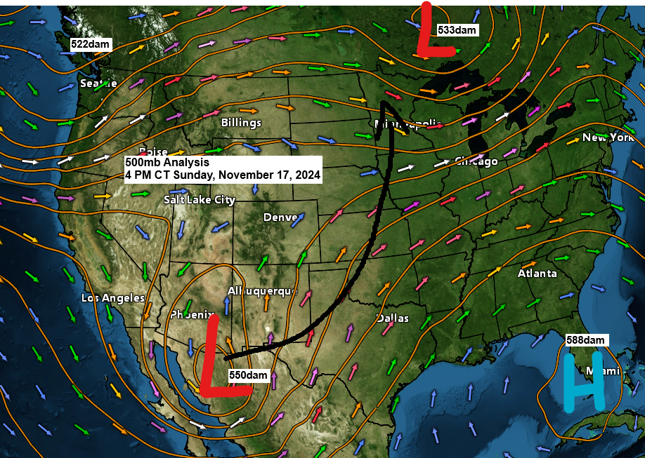
Upcoming Rainy and Windy Conditions: Long Range Snow Forecasts
6:00 PM Sunday, November 17, 2024 A potent low-pressure area (<990mb) is forecasted to move rapidly northward from northern Mexico in the coming days. This system is anticipated to arrive in south-central Minnesota by daybreak on Tuesday, before progressing northward across the state throughout the day.
-
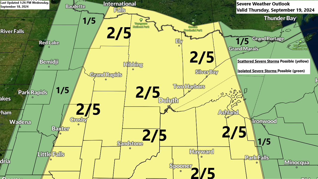
Severe Thunderstorm Forecast for Northeast MN & NW WI
6:40 PM Wednesday, September 18, 2024 Northeast Minnesota and northwest Wisconsin may experience isolated to scattered strong to severe thunderstorms on Thursday, especially in the afternoon to early evening hours. The highest risk is indicated by yellow, signifying a slight risk, or level 2 out of 5, for severe thunderstorms.
-
Severe Weather and Tornadoes Hit Minnesota and Wisconsin | August 29, 2024 Reports
5:24 PM Friday, August 30, 2024 Just a reminder: my blog has implemented a paywall. If you appreciate the content, please consider subscribing. The options are a monthly subscription at $5 or an annual one for $60. Your support is greatly valued. Currently, I have 11 paid subscribers. A heartfelt…