Tag: fire danger
-
Burning Restrictions expand across central and northern Minnesota; Update on the Greenwood Fire
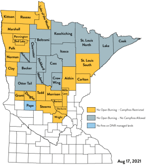
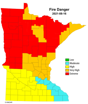
12:01 PM 8/17/2021 34 counties in Minnesota are now under burning restrictions as of 12:01 AM Tuesday, August 17, 2021. Intensifying drought has elevated the potential for devastating wildfires in parts of central and northern Minnesota. Fire danger for Tuesday, August 17, 2021 is rated as Extreme (red) to Very…
-
Greenwood Fire Update
11:30 AM Monday, 8/16/2021 All of the information below is from the Ely Echo Greenwood fire is on track to head toward Highway 1 after Sunday night’s activity. There are 6 fire departments protecting structures in the McDougal Lake area including Morse-Fall Lake, Ely, Babbitt, Silver Bay, Two Harbors and…
-
Critical Fire Weather Conditions expected this afternoon in northeast Minnesota
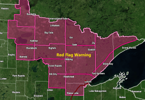
Critical Fire Weather Conditions are expected this afternoon across northeastern Minnesota, with low relative humidity, strong wind gusts, and dry fuels which will be favorable for rapid fire growth. A Red Flag Warning is in effect for northeast Minnesota from 1 PM this afternoon to 6 PM this evening. Winds:…
-

Warm and Humid with scattered showers/t-storms thru Friday night (A few strong to severe storms possible Friday) >70% of Minnesota in Severe Drought; Warm pattern sticks around through next week
Rain chances continue across the Northland through Friday night, so hopefully a lot of us will get at least some rain over the next 24-36 hours since this is the best setup we’ve seen around here in weeks. Will have a few sources of lift (fronts) moving through the area…
-
Scattered showers and thunderstorms tonight/early Thursday morning (a few strong to severe storms possible) Warm but mainly dry Thursday
A few strong to severe thunderstorms remain possible across northeast Minnesota and northwest Wisconsin tonight as a cold front moves through the area. Storms are expected to develop this evening in far northern Minnesota with storms moving east or east-southeast overnight. Note: Timing for when we could get some thunderstorms…
-
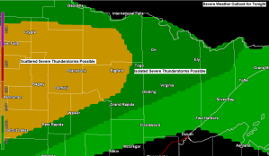
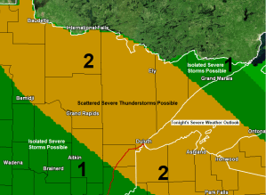
A few strong to severe thunderstorms possible in northern Minnesota late tonight-Tuesday morning; warm and more humid the next few days (cooler near Lake Superior) Additional chances for a few showers/t-storms thru Friday
There is a chance for some severe weather late tonight across northern Minnesota. The main hazard is from damaging wind gusts to 60 mph, with a lesser chance for hail to quarter size (1″ diameter) The risk for thunderstorms and possibly a few severe thunderstorms is greatest north and northwest…
-

Warm weather continues this week (cooler at times near Lake Superior) A few showers/t-storms possible, but a lot of us stay dry thru midweek
A very warm weather pattern lingers this week with daytime highs in the Northland in the 80s to lower 90s, but we will have some days which will have an easterly wind, and when that happens, temperatures will be a lot cooler within about 10 to 15 miles of Lake…