Tag: high winds
-
A winter storm is set to roll in Tuesday evening.
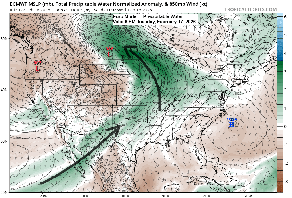
The winter storm moving in Tuesday evening will bring plenty of moisture, with a plume stretching northeast from the Baja region and additional moisture streaming up from the Gulf. PWATs of 0.5 to 0.75 inches are expected across much of the Northland Tuesday night into Wednesday morning, which is unusually…
-
Rain, Snow, Sleet, patchy Freezing Rain and Wind on the way
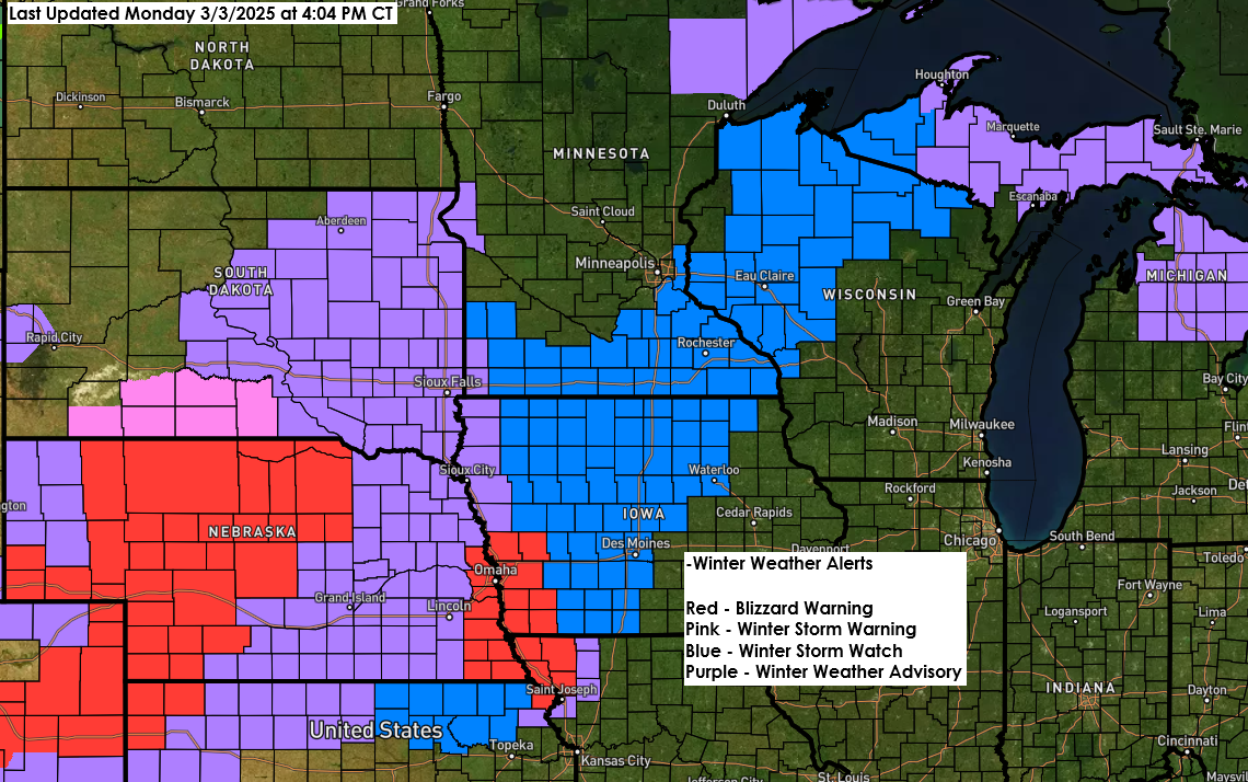
5:32 PM Monday, March 3, 2025 Wintry weather returns to parts of the Northland the next few days. From a dynamics view, this looks like a strong system with two jet streaks (areas of high winds) and a trough moving northeast into the upper Midwest, which becomes more negatively tilted…
-

Cold and Windy with areas of blowing snow through this weekend – Blizzard Warning issued for the North Shore and for much of the South Shore; Wind gusts 50-70 mph along the North Shore Friday-Saturday; Snowfall Reports from Dec. 21-22; Warming trend later next week
5:46 PM Thursday, December 22, 2022 -Strong north to northwest winds will produce widespread blowing snow in the Northland over the next few days. -Wind gusts of 25 to 45 mph will be common in the Northland tonight through Sunday morning, with stronger wind gusts of 50 to 70 mph…
-

Rain and wet snow Sunday-Monday morning (greatest snow amounts north of Duluth) A powerful spring storm brings high winds, rain, thunderstorms and wet snow to the Northland Tuesday PM-Thursday
6:34 PM Saturday, April 9, 2022 A very active weather pattern returns starting Sunday night. A quick moving but potent low-pressure system is forecast to lift NE out of the Central Plains on Sunday. This low moves into southern Minnesota Sunday evening, and moves to near Thunder Bay Canada by…
-
Storm Summary for December 15-16, 2021 (Tornadoes confirmed in MN and WI Wednesday evening) Cold tonight; A little snow possible late Friday-early Saturday
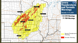
A major severe weather outbreak occurred Wednesday into early Thursday, December 15-16, 2021, with 118 severe thunderstorm warnings and 71 tornado warnings issued by various NWS locations in the Central Plains and upper Midwest. An incredible number of warnings for mid-December! Just your typical Derecho in DECEMBER, wait, what? The…
-
A powerful storm on the way late Wednesday into early Thursday bringing rain, a risk for severe t-storms (isolated tornadoes), snow, widespread high winds (power outages), rapidly falling temperatures (possible flash freeze), and hurricane force wind gusts over parts of Lake Superior
A powerful storm will impact the upper Midwest from late Wednesday into early Thursday. This storm will bring a variety of hazards to the Northland, including rain, fog, snow, falling temperatures, possible flash freeze, thunderstorms, high winds and possible power outages. I’ll break down each one of these hazards in…
-

A fast moving but powerful storm set to hit the Northland with a variety of impacts possible for late Wednesday-early Thursday
One more quiet day ahead for Tuesday which will be followed by a brief period of active weather for Wednesday into early Thursday as a powerful area of low pressure moves quickly to the northeast out of the Rockies and Western High Plains — This system looks to bring a…