Tag: lake effect snow
-

Snow continues tonight followed by a brief shot of arctic air for Monday and Tuesday; Strong winds and areas of blowing snow tonight and Monday
4:56 PM Sunday, December 5, 2021. Wind, areas of blowing snow and falling temperatures will become the main weather issues in our area through Monday as snow begins to taper off early Monday morning, except in the snowbelt region of northwest Wisconsin (portions of Ashland and Iron Counties) where lake…
-
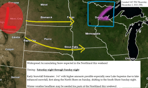
A little snow possible late tonight into Friday; More snow possible Saturday night into Sunday followed by a brief shot of arctic air for early next week
Another clipper system will move across the area tonight and Friday bringing a little snow to parts of the Northland with accumulations of generally a dusting to an inch expected by Friday afternoon. Mainly dry weather is expected Friday night through the day Saturday before more snow moves in Saturday…
-

Blustery! Very cold tonight and Thanksgiving; Lake effect snow showers for the South Shore and a few flurries elsewhere tonight; Sunshine Thursday
A much colder air mass is pushing south out of central Canada and into the Northland this afternoon and this cold air will be with us into Friday before we see milder temperatures return this weekend. The coldest day will be on Thanksgiving, this is when daytime highs will only…
-

Chilly temps for now, but a warming trend begins late this week; A little rain possible Friday night followed by a potentially larger system for mid-late next week
Cool temperatures will stick around in the Northland on Wednesday with highs in the upper 30s to lower 40s, but after that it’s all uphill (at least for a little while) as we see high temps climb well into the 40s on Thursday, and reaching the low to mid 50s…
-

Scattered snow showers or mixed rain-snow showers linger into Tuesday; Chilly into midweek; 50 degree temps return late this week into this weekend
The Northland will continue to see some snow showers, flurries or mixed rain-snow showers at times into Tuesday. Some of these snow showers could be heavy for brief periods of time this evening especially across northern Minnesota with visibilities dropping to a mile or less for brief periods of time.…
-

Areas of fog possible late tonight; Mild temps continue Saturday followed by colder temps and some snow showers early next week; Warmer weather could return 2nd week of November
Areas of fog may redevelop over parts of the Northland late this evening lingering into Saturday morning, with any fog and low clouds expected to burn off by Noon Saturday. 18z HRRR model visibility forecast shows the potential for reduced visibilities to <1 mile from fog (darker colored areas) over…
-

Some rain lingers into Thursday; Turning colder Halloween through most of next week with a few snow showers possible
Rainfall Reports from Wednesday, October 27, 2021 Source: https://mesowest.utah.edu/ Totals listed below are thru 4 PM Wednesday. Minong, WI: 0.47″McGregor, MN: 0.40″Duluth Sky Harbor Airport: 0.38″Superior Airport: 0.26″Solon Springs, WI: 0.23″Cass Lake, MN: 0.21″Duluth Airport: 0.19″Two Harbors, MN: 0.12″Pine River, MN: 0.12″Grand Rapids, MN: 0.11″Chisholm-Hibbing Airport: 0.08″Barnes, WI: 0.07″Siren, WI:…