Tag: severe risk
-
A few chances for showers/t-storms through Thursday with seasonable temperatures
5:35 PM Monday, June 27, 2022 Local Storm Reports for June 27, 2022Source: NWS Duluth, MN 5:19 PM: Hail 1.25″ (half dollar size). Beroun, MN (Pine County) A lot of accumulated hail on the roadway. 5:08 PM: Hail 0.88″. 2 ENE Brook Park, MN (Pine County) 4:22 PM: Hail 2.00″…
-

A fast moving but powerful storm set to hit the Northland with a variety of impacts possible for late Wednesday-early Thursday
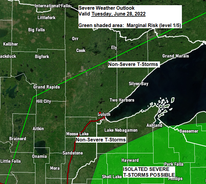
One more quiet day ahead for Tuesday which will be followed by a brief period of active weather for Wednesday into early Thursday as a powerful area of low pressure moves quickly to the northeast out of the Rockies and Western High Plains — This system looks to bring a…
-

Pea soup fog continues near Lake Superior tonight; muggy Saturday with scattered showers and t-storms (few strong to severe storms possible) more rain chances next week
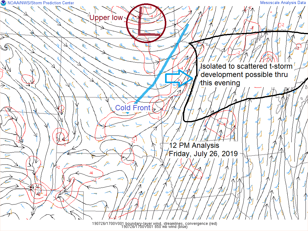
Source: https://www.spc.noaa.gov A strong trough of low pressure is lifting slowly NE across the central-northern Rockies today. We’ve seen clusters of strong to severe thunderstorms erupt out ahead of this trough today from parts of North Dakota into far northwest Minnesota. Source: Goes-16 Lower Level Water Vapor imagery; https://weather.cod.edu Radar…
-
A few strong to severe t-storms possible through early this evening; rainfall reports from Thursday PM-Friday AM
Rainfall reports from around the Northland for July 25-26, 2019 Note: Totals listed below are for the 24 hour period ending at 7 AM Friday, July 26. Source: https://www.weather.gov/dlh/ Embarrass: 0.78 inch Grand Marais: 0.72 inch 10 W Gunflint Lake: 0.70 inch Brainerd: 0.70 inch Babbitt: 0.67 inch 25 E…
-
Scattered showers/t-storms possible the next few days; warm temps continue, turning more humid Thursday-Friday
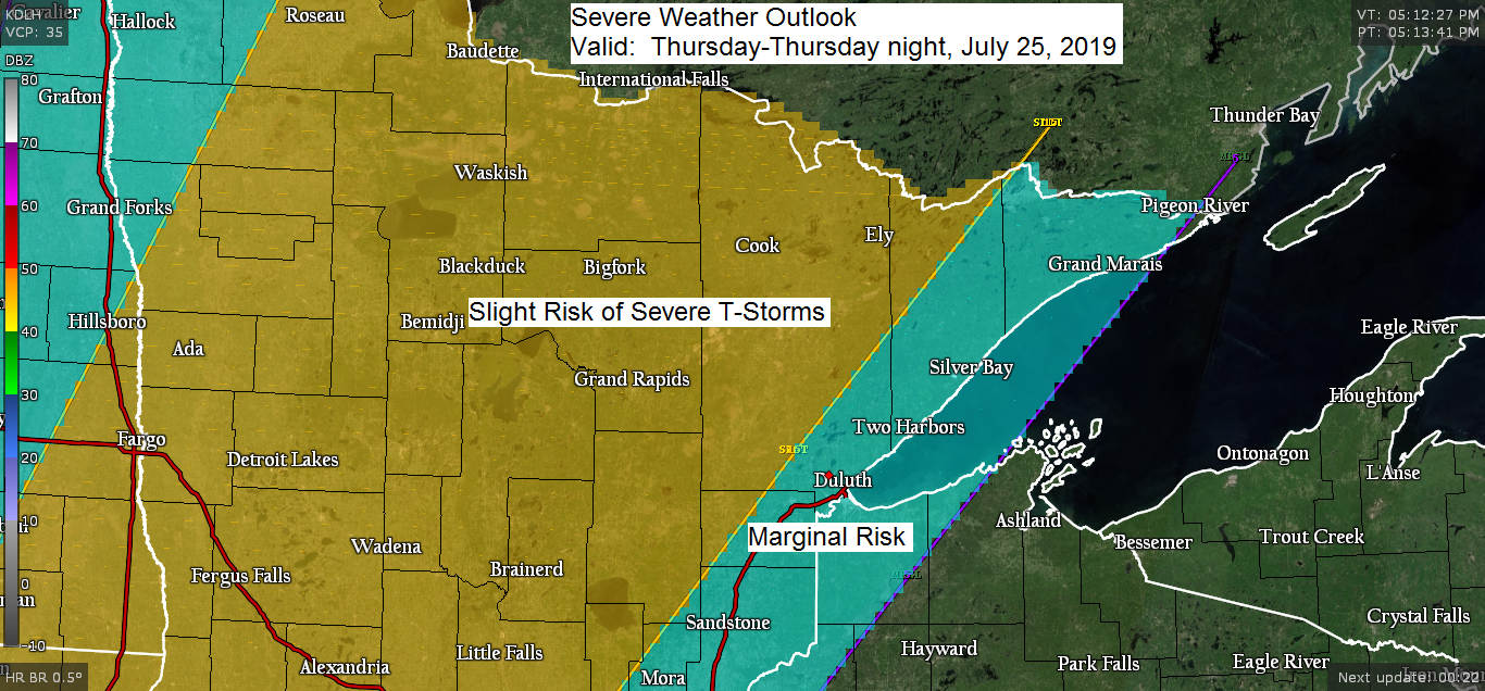
All of north-central Minnesota is in a Slight risk of severe thunderstorms Thursday and Thursday night. Marginal risk of severe thunderstorms Thursday and Thursday night farther east (light blue shaded area on map) …Hazards in the risk areas include… Large hail to 1 inch in diameter (quarter size) Damaging wind…
-

Risk for strong to severe t-storms Friday in eastern MN and northern WI
Northland Storm Reports for July 17-18, 2019 2:33 PM (7/18) TORNADO — 11 miles ENE Gordon, WI (Douglas County) 12:00 PM (7/18) HAIL — 1.25 inch. Foxboro, WI (Douglas County) Half dollar size hail. 9:48 PM (7/17) HAIL — 0.25 inch. 7 WSW Hovland, MN (Cook County) 8:30 PM (7/17)…
-
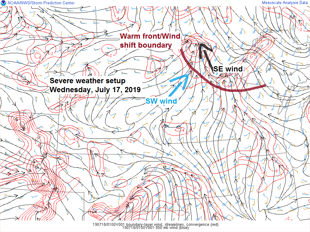
Northland Storm Reports for Wednesday, July 17, 2019
Note: Additional storm reports could continue to come into the National Weather Service through the night, and if that happens I’ll send out another storm reports blog post on Thursday from today’s severe weather event. 8:30 PM: FUNNEL CLOUD — 4 NE Orr, MN (St. Louis County) Funnel cloud spotted…