Tag: wind advisory
-
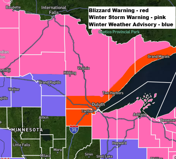
Blizzard conditions are expected on the North Shore from tonight through Friday morning.
Note: For a storm to qualify as a blizzard, three conditions must occur for at least three straight hours: winds over 35 mph, visibility under a quarter mile, and falling or blowing snow. …Blizzard conditions along the North Shore… East to northeast winds will keep picking up tonight, with gusts…
-

Strong winds Friday; Arctic air returns this weekend
Windy weather is on the way for Friday as a strong cold front passes through the Northland while a deep low pressure system tracks east across Ontario. Northwest winds will increase with gusts of 25 to 50 mph across the Northland, with the strongest winds across northeast Minnesota. The Arrowhead,…
-
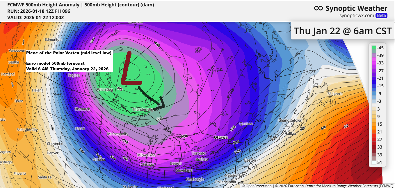
A frigid week is on the way, with the Polar Vortex making an appearance later in the week.
With Duluth possibly hitting 30 below or even colder later this week, here’s a look back at the years since 1990 when temperatures that frigid have occurred in the city. Note: Last winter in Duluth, the lowest temperature was a frigid -27°F on January 21, with February 12 not far…
-
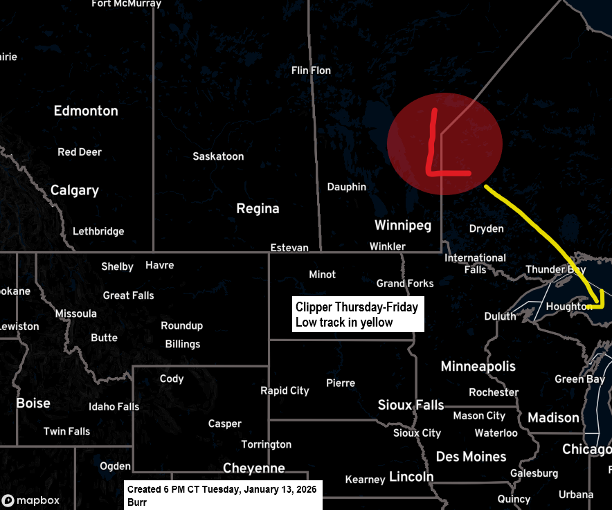
Colder weather is moving in, with a chance of snow later this week.
An unusual-looking clipper system is set to move southeast from western Ontario on Thursday, cross central Lake Superior Friday, and arrive in lower Michigan by Saturday. It’s expected to bring occasional snow to northeast Minnesota and northwest Wisconsin from Thursday afternoon into Friday. But since it’s coming from Canada with…
-

Cold weather with a few chances for snow ahead
In 2025, my blog welcomed a total of 20,079 visitors, with December and March being the top two months for views. Over the year, I published 363 posts, totaling 146,162 words. Thanks to everyone who stops by, whether daily or when the weather gets interesting—I truly appreciate each and every…
-
12 PM Weather Report – December 27, 2025
There’s a big disagreement brewing in the computer models this morning for Sunday’s system. The Canadian, ICON and UK models, along with the Euro AI model to some extent, are showing a sharp cutoff in snowfall developing in parts of the Northland. Meanwhile, other models like the Euro, NAM, RAP,…
-
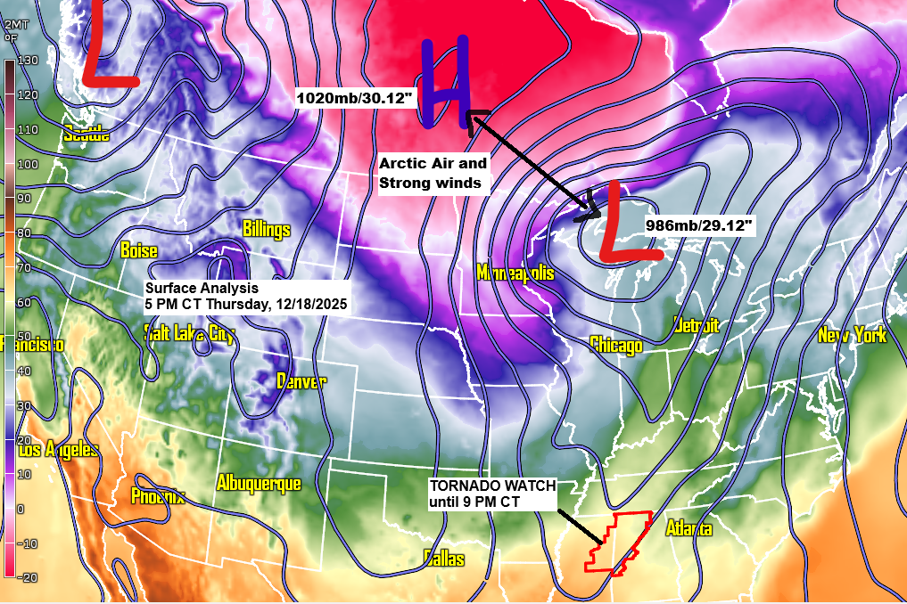
Strong winds and subzero temperatures tonight with lingering snow, followed by more bursts of arctic air and gusty winds over the weekend.
Early this evening, a strong low-pressure system pushed into the eastern side of Lake Superior as high pressure moved in from the northwest. The steep pressure difference between them is kicking up strong northwest winds across the Northland, boosted by a rush of cold air. By 5 PM, 850mb temperatures…