Month: July 2020
-

Cool tonight with patchy fog late; pleasant weather for Thursday; muggy Friday through Sunday with a few storms possible
A cool night ahead as clouds continue to decrease across the Northland late this afternoon. The combination of mostly clear skies and light winds later tonight should result in temps falling into the 40s and 50s in northeast Minnesota and northwest Wisconsin early Thursday morning, and it’s even possible that…
-
Near to below normal temps continue Wednesday; turning warmer and more humid Friday-Sunday with dew points 70+ degrees!
It’s been a while since we’ve had a day that was this cool and rainy across the Northland, and just think a few months from now a system like today’s would bring significant snow and wind to the Northland, but I digress. -Scattered showers and thunderstorms with downpours, funnel clouds,…
-

Two EF-1 Tornadoes in northwest Wisconsin early Saturday morning (July 18th) Breezy and cool on Tuesday with some rain; turning warmer and more humid this weekend
Two EF-1 Tornadoes in northwest Wisconsin early Saturday morning. Source: https://www.weather.gov/dlh/ Tornado #1 – Maple/Blueberry, Wisconsin Rating: EF-1 Estimated Peak Wind: 100 mph Path Length: 0.4 miles Path Width: 50 yards Start Date: July 18, 2020 Start Time: 1:48 AM CDT Start Location: 2 miles north of Blueberry/Douglas county WI…
-

Rain chances return Tuesday; turning warmer and more humid late week; additional storm reports from July 18, 2020
Pleasant and less windy weather is expected across the Northland for Monday with highs mainly in the 70s. Another low pressure system arrives Monday night into Tuesday bringing another round of rain to northeast Minnesota and northwest Wisconsin. Model guidance shows potential for widespread half to one inch rainfall totals…
-

Storm Reports from Saturday evening, July 18, 2020
Another round of severe thunderstorms impacted portions of northeast Minnesota and northwest Wisconsin late Saturday afternoon into Saturday evening with numerous reports of large hail and damaging winds. There was one report of 3″ diameter hail near Shaw, Minnesota around 7:30 PM Saturday, that is bigger than a baseball! Also…
-
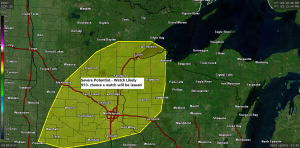
Mesoscale Discussion issued for parts of the Northland – Watch likely!
3:23 PM – A Mesoscale Discussion for Severe Weather has been issued for Minnesota and northwest Wisconsin with a 95% chance that a watch will be issued for parts of central, eastern and southern Minnesota and western Wisconsin over the next few hours. Storm Prediction Center Mesoscale Discussion link –…
-

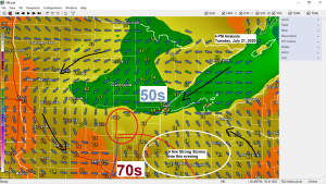
Another round of thunderstorms possible late this afternoon/this evening, a few could be strong to severe
1:32 PM CT – There is an Enhanced Risk for Severe Thunderstorms late this afternoon into this evening over eastern Minnesota and for parts of northwest Wisconsin, roughly from Aitkin to Mahtowa, east to Lake Nebagamon, then south to Cable and Winter, this includes the Hayward lakes area as well.…