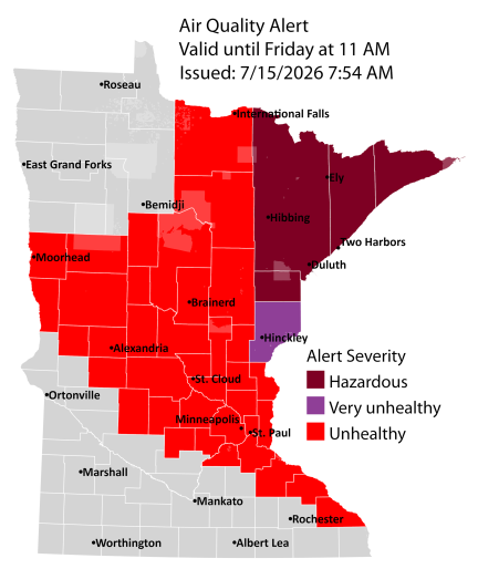
An air quality alert remains in effect until 11 a.m. Friday for all of northeast Minnesota and until noon Thursday for all of northwest Wisconsin, with the possibility of extensions in both states.
Fires are still burning in far northeast Minnesota and northern Ontario, Canada, sending thick, hazardous smoke south into the Northland.
Light traces of ashfall are likely and have already been spotted in areas with dense smoke.
Here’s a rundown of some of the larger fires burning in far northeastern Minnesota, impacting areas from northern St. Louis to northern Lake Counties. As of Wednesday afternoon, none of these fires are contained.
- Thumb Fire: 14,500 acres
- Bear Trap Fire: 13,500 acres
- Sioux Fire: 6,922 acres
- Wolfpack Fire: 3,274 acres
- Camp Fire: 2,886 acres
- Echo 2 Fire: 16.4 acres
Evacuation orders as of Wednesday afternoon, July 15, 2026
Go – Level 3 – Evacuation Order (red shaded areas)
Set – Level 2 – Evacuation Warning (yellow shaded areas)
Ready – Level 1 – (green shaded areas)

Air quality is extremely poor this afternoon across much of northeast and eastern Minnesota, as well as all of northwest Wisconsin. Thick wildfire smoke settled over the Northland last night and is still hanging around, making conditions hazardous all day.
In Duluth, AQI levels ranged from 415 to as high as 581 late Wednesday afternoon, and earlier in the day, an AQI over 900 was recorded, which is truly off the charts.
Reports have also come in of ash falling from the sky in parts of the Northland today, caused by the thick smoke.


…Smoke Trends…
Thick wildfire smoke is expected to linger over northeast Minnesota and northwest Wisconsin at least through Friday morning with some of the most hazardous conditions in those red and purple areas on the loop below.
What happens Friday afternoon and beyond is still up in the air, as it will depend on factors like how much rain falls over the fires in the next few days and how the wind shifts from Friday into the weekend. There’s a chance that more smoke could affect parts of the Northland through the weekend, but right now the severity and exact locations are uncertain.
HRRR model near-surface smoke density forecast through 1 PM Friday.

A few showers passed through the fire zones this afternoon, but they hardly made a difference, with measurements showing just 0.01 inch of rain in Meander, MN today.

Since June 1st, far northern Minnesota, including the Arrowhead region (blue outlined area), has received about 3 to 5 inches less rainfall than average.

…Rainfall Potential through Friday…
Forecasts vary for rainfall in the fire zones through Friday afternoon, with the HREF model showing higher amounts—generally a quarter to half an inch or more, with some spots possibly getting over an inch.
Note: One thing seems pretty certain: we probably won’t see any rain in Duluth at least through early Friday afternoon.

Meanwhile, the Euro forecast is much drier, with rain totals generally under 0.15 inches in the fire zones through Friday afternoon.

The NWS Blend of Models is predicting about 0.10 to 0.25 inches of rain through Friday afternoon in the fire zones, with a few spots possibly seeing higher amounts of 0.50 inches or more.

…Temperature Trends…
Cooler temperatures made their way into the Northland today, with 24-hour temperature drops of about 10 to 20 degrees.

With that said, highs were still on the warm side ranging from the mid 70s in far northern Minnesota and Arrowhead region, with 80s farther south.
On July 15th, Duluth marked its seventh straight day with highs of at least 80 degrees and its twelfth day this month hitting 80 or warmer. Usually, the city sees around 11 days at or above 80 in all of July.
The next few days will stay warm, with highs in the 70s and 80s, and some spots possibly hitting the 90s, especially from Friday into the weekend.

Leave a Reply