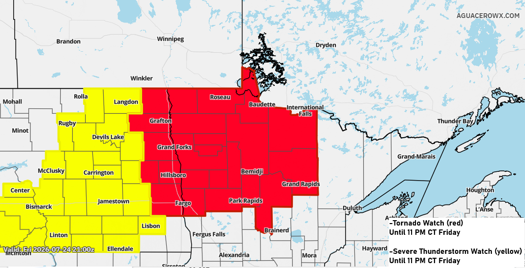
Strong to severe thunderstorms are expected tonight across parts of northwest and north-central Minnesota, extending into areas of North Dakota.
Northwest and north central Minnesota could get hit with massive hail, possibly up to the size of baseballs, along with damaging winds reaching 60–80 mph. A few tornadoes might also develop this evening, especially in the northwest part of Minnesota. As the storms move farther south and east later tonight, they’ll probably weaken before possibly making it to northeast Minnesota and northwest Wisconsin.
Looking at the severe weather parameters late this afternoon, the most favorable environment for storms tonight appears to be over northwest and north-central Minnesota. There’s less instability, or storm fuel, for them to keep their strength once they move into northeast Minnesota and northwest Wisconsin later tonight.

Showers and thunderstorms are expected to move east-southeast over northern Minnesota tonight and may reach Duluth after midnight. The rain is likely to clear out by 5-7 AM on Saturday.
HRRR model simulated radar forecast through 9 AM Saturday.
Some areas of northern Minnesota could see 1 to 2 inches or more of rain tonight, with a chance of localized flash flooding. Farther south, including the Duluth area, rainfall amounts are expected to be much lower.

Radar loop ends 5:29 PM Friday, July 24, 2025.
Goes-19 sandwich satellite loop from Friday, July 24, 2026, loop time ends 5:16 PM CT.

Tonight’s storm chances come from a weak boundary moving east from the central Dakotas. This front will mostly fizzle out before reaching the Northland, but another cold front is set to drop south from Ontario into northern Minnesota on Saturday, and it will shift north and south through Monday.
Overall, the weekend forecast is uncertain due to the chance of scattered showers and thunderstorms, which could keep temperatures slightly cooler if they materialize.
It looks like the Northland will see mostly dry weather during the day on Saturday, with a chance of some passing storms on Sunday.
High temperatures on Saturday and Sunday will be in the 80s, but could reach the 90s with enough sun. If storms develop more than expected, highs may be cooler in the 70s and 80s.

It’s shaping up to be a pretty humid weekend, with dew points in the 60s and possibly climbing into the 70s. However, there’s a chance some drier air could mix in at times, bringing dew points down to the 50s or lower 60s.

Leave a Reply