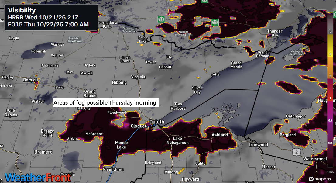
It looks like some fog may develop in parts of northeast Minnesota and northwest Wisconsin later tonight, lingering into Thursday morning. This should clear by Thursday afternoon, though some clouds might stick around, especially near Lake Superior.
This afternoon in the Northland, temperatures ranged from the mid-60s to the low and mid-70s, continuing our stretch of mild weather.
Locations even along the Lake Superior shoreline reached the upper 60s to near 70 degrees today as winds shifted from the northeast to the northwest. However, the cooler northeast wind has returned and is expected to persist through Friday, keeping lakeshore temperatures mainly in the 50s. Farther inland, milder weather will continue, with afternoon highs in the 60s and 70s through Saturday.
Today’s high of 70 in Duluth on October 21, 2026, marked the fourth time this month the temperature reached at least 70 degrees. The October average is just two days at or above 70, while the record is 12 days, set in October 1963.

Here’s a look at the dates when Duluth recorded its final 70-degree day each year from 2020 to 2025.
2025: October 5
2024: October 21
2023: October 3
2022: November 2
2021: October 19
2020: November 6
Note: In Duluth, the average date for the last 70-degree day is October 10, according to climate data from 1874 to 2025.
A cold front will move through the Northland on Saturday, bringing a chance for isolated to scattered rain showers beginning Friday night and continuing into Saturday. While a few areas may pick up some rainfall, this does not appear to be a widespread or long-lasting rain event. Beyond that, precipitation chances look fairly limited across the Northland over the next 5 to 7 days.
There continues to be a potential system showing up in model guidance for early next week, but there are still considerable differences regarding its track, how far north any precipitation may extend, and whether it will affect northeast Minnesota or northwest Wisconsin at all. If that system does impact the region, the most likely timeframe would be sometime between Sunday night and Tuesday.

Today’s main headline is the showers, thunderstorms, and severe weather impacting parts of the southwest U.S.
A tornado watch (red box) is in effect for the northern half of Arizona until 8 PM CT, while a severe thunderstorm watch (yellow box) remains in place until 11 PM CT.
The MRMS radar loop from Wednesday, October 21, 2026, concludes at 5:58 PM CT.
A powerful system is affecting the southwest U.S. today, with another equally impressive one over the Atlantic.
GOES-East water vapor loop from Wednesday, October 21, 2026, ending at 5:55 PM CT.
Leave a Reply