Category: blizzard warning
-
5 PM Weather Update – Updated Snowfall Forecast
Let’s get straight to the point, since most are eager to know how much snow I expect by Wednesday afternoon, though there’s plenty to cover in today’s blog. Twin Ports area Snow totals remain about the same, with 6 to 9 inches expected in higher elevations and 3 to 6…
-
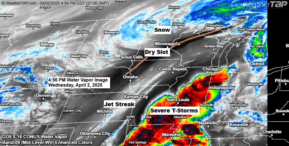
Winter Storm Update (5 PM Wednesday)
5:17 PM Wednesday, April 2, 2025 Based on the snow reports that have come in today, it’s looking like this will be another failed snowfall forecast for Duluth and possibly in other parts of the Northland as well. However, with snow ongoing late this afternoon, we will see what we…
-

Winter Storm misses the Northland to the south on Wednesday; Another system Sunday with snow/rain
6:10 PM Tuesday, March 18, 2025 Remember back in the winter of 2022-2023 when it seemed like every single weather system took a favorable track to bring snow to Duluth, and by the time it ended, we ended up with around 140 inches of snow that winter. Well, this winter…
-

Minnesota Weather Alerts: Blizzard and Thunderstorm Risk
5:05 PM Friday, March 14, 2025 Some of the same areas in southwest and west-central Minnesota that are seeing temperatures in the 60s and 70s this afternoon are under blizzard warnings on Saturday. Various winter weather alerts cover western and northern Minnesota for Saturday, including a winter storm warning for…
-

Deepening Low Pressure Brings Snow and Windy Conditions
6:20 PM Tuesday, March 4, 2025 A very dynamic storm will continue to lift northeast out of Missouri tonight. A low-pressure system of 986mb over western Missouri this afternoon will move northeast toward Chicago, IL by mid-morning Wednesday, and will reach Lake Huron by Wednesday evening. The central pressure is…
-
Rain, Snow, Sleet, patchy Freezing Rain and Wind on the way
5:32 PM Monday, March 3, 2025 Wintry weather returns to parts of the Northland the next few days. From a dynamics view, this looks like a strong system with two jet streaks (areas of high winds) and a trough moving northeast into the upper Midwest, which becomes more negatively tilted…
-

Snow tonight; Gusty winds Thursday
6:12 PM Wednesday, February 5, 2025 -Snow tonight, with moderate to heavy snowfall rates of 0.50 to 0.75 inches per hour at times. -Snow ends from southwest to northeast early Thursday morning. -East winds near Lake Superior gusting to 25 mph will cause patchy blowing snow tonight. -Gusty west winds…