Tag: flood watch
-

Rainy at times through the weekend; Wet Snow with significant accumulations possible in parts of northern Wisconsin and far northeast Minnesota late Saturday night-early Monday; Flood Watch in effect for parts of the Northland
6:35 PM Friday, April 28, 2023 A significant late season winter storm is possible in parts of northern Wisconsin and western/northern portions of upper Michigan (South Shore area) beginning late Saturday night and lingering into Monday. A slow moving and strong surface and upper level-low pressure system will move northeast…
-
Wet and Cool through early next week; Flood Watch in effect for parts of the Northland through Sunday; Gusty NE winds near Lake Superior late tonight-Friday; Rainfall and Snowfall Reports from Wednesday night-early Thursday morning
6:19 PM Thursday, April 27, 2023 We’re heading back into an unsettled and cool pattern in the Northland through early next week as another large and slow-moving surface and upper level low/trough stalls out over the Great Lakes. This system will bring occasional precipitation to northeast Minnesota and northwest Wisconsin…
-

Turning Windy and Colder near Lake Superior Thursday; Much warmer temps continue inland through Friday; Scattered showers/t-storms in northern MN Thursday-Friday; Rain chances this weekend with some snow also possible; Flood Update; 90 degree temps reported in southern Minnesota today; 80s in parts of northwest Wisconsin
8:48 PM Wednesday, April 12, 2023 Much cooler temperatures along with strong northeast winds are on the way near Lake Superior for Thursday and Friday with highs both days ranging from the upper 30s to middle 40s within about 15-20 miles of Lake Superior. Northeast winds will also increase with…
-
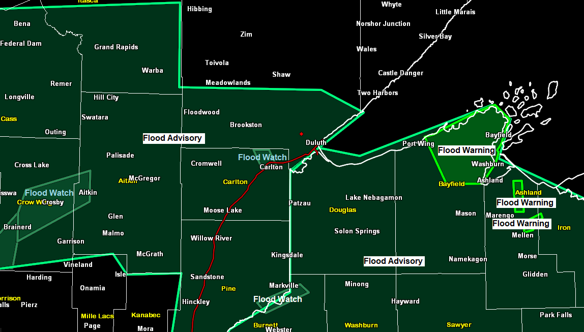
Flood Update — Flood Warnings and Watches issued for parts of the Northland; Very warm Wednesday; Turning much cooler near Lake Superior (gusty NE winds) Thursday and Friday, but still mild inland; Wetter pattern possible late week/this weekend with some snow also possible
8:22 PM Tuesday, April 11, 2023 Flood Headline information — Source, National Weather Service Duluth, Minnesota. Flood Warnings issued for parts of northwest Wisconsin *Flood Warning for snowmelt until 4:15 PM Thursday for a portion of northwest Wisconsin including Bayfield. -Flooding of rivers, creeks, streams, and other low-lying and flood-prone…
-
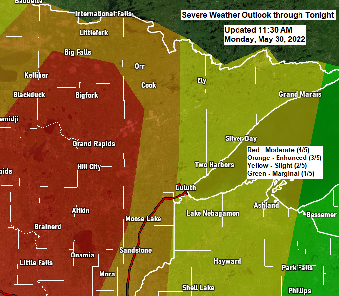
Update on the potential for severe thunderstorms for late this afternoon/this evening; Rainfall and Storm Reports from Monday morning
1:14 PM Monday, May 30, 2022 Widespread severe thunderstorms are expected in much of north-central Minnesota late this afternoon into this evening, with scattered to numerous severe thunderstorms expected in much of northeast into far eastern Minnesota with scattered severe thunderstorms in much of northwest Wisconsin. In addition to the…
-

Flood Watch issued for parts of the Northland; Rounds of showers and thunderstorms through Monday night with a threat for heavy rain (flooding) and a risk for some strong-severe storms
10:49 AM Sunday, May 29, 2022 Flood Watch in effect through Tuesday morning for parts of north-central and northeast Minnesota including the cities of Pine River, International Falls, Ely, Brainerd, Hill City, Grand Rapids, Walker, and Bigfork. Flash flooding caused by excessive rainfall possible. Several rounds of thunderstorms are expected…
-

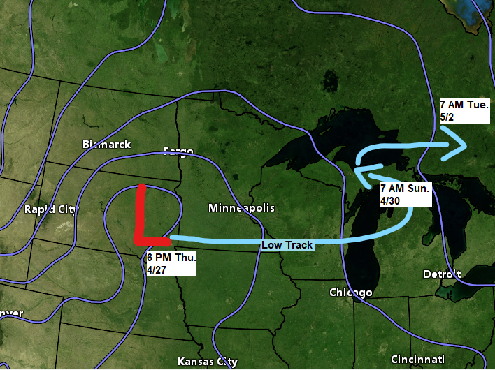
More rain and wind through Sunday, strongest winds near Lake Superior; Flood warning/watch in effect for parts of the Northland; April 2022 wettest April on record at International Falls; A stretch of dry weather ahead after Sunday
7:47 PM Saturday, April 30, 2022 Strong northeasterly winds will continue near Lake Superior and in the Twin Ports tonight into Sunday morning with diminishing wind speeds Sunday afternoon, but until then expect wind gusts of 25 to 45 mph to continue. Occasional rain and drizzle through Sunday evening with…