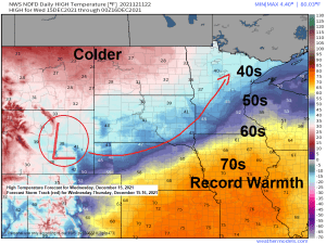
Tag: Record Warmth
-
Storm Summary for December 15-16, 2021 (Tornadoes confirmed in MN and WI Wednesday evening) Cold tonight; A little snow possible late Friday-early Saturday
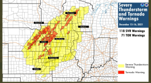
A major severe weather outbreak occurred Wednesday into early Thursday, December 15-16, 2021, with 118 severe thunderstorm warnings and 71 tornado warnings issued by various NWS locations in the Central Plains and upper Midwest. An incredible number of warnings for mid-December! Just your typical Derecho in DECEMBER, wait, what? The…
-

A fast moving but powerful storm set to hit the Northland with a variety of impacts possible for late Wednesday-early Thursday
One more quiet day ahead for Tuesday which will be followed by a brief period of active weather for Wednesday into early Thursday as a powerful area of low pressure moves quickly to the northeast out of the Rockies and Western High Plains — This system looks to bring a…
-
Mild and dry the next few days; Midweek rain chances followed by a cooling trend
A less active weather pattern will be with us for the next few days. High temperatures in the Northland for Sunday, Monday and Tuesday will mainly be in the 30s, although a few locations may hit 40 degrees on any one of those days. Normal highs in mid-December are in…
-
A major winter storm continues from south-central Minnesota to central Wisconsin tonight; Mild temps and a quieter weather pattern this weekend into early next week; Storm potential middle of next week
A powerful area of low pressure centered over far northeast Kansas late this afternoon will lift northeast reaching central Lake Michigan by daybreak (Saturday), this low will then move into western Quebec by Saturday evening. Heavy snow in the colder air on the NW side of this low, while severe…
-
Winter Storm to hit parts of the upper Midwest Friday-early Saturday, northern fringes of this storm to impact parts of northwest Wisconsin; A quieter weather pattern this weekend into early next week; Powerful storm possible ~December 15-16
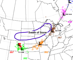
A major winter storm is set to hit the southern half of Minnesota into central and northeast Wisconsin into much of upper Michigan Friday into Saturday morning. The heaviest snowfall accumulations with this storm are expected to stay south of the Northland, but some snow accumulation is likely as far…
-
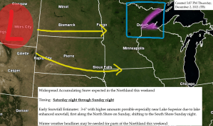
A little snow possible late tonight into Friday; More snow possible Saturday night into Sunday followed by a brief shot of arctic air for early next week
Another clipper system will move across the area tonight and Friday bringing a little snow to parts of the Northland with accumulations of generally a dusting to an inch expected by Friday afternoon. Mainly dry weather is expected Friday night through the day Saturday before more snow moves in Saturday…
-
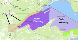
Turning Windy tonight, wind advisory in effect for the North Shore (Storm and Gale Warnings in effect for Lake Superior)
An active weather pattern continues in the Northland. Gusty winds tonight into Thursday morning, with another round of gusty winds possible Friday. A few rain and snow showers tonight and Thursday followed by a potential for a minor snow event which may hit parts of the Northland Thursday night/Friday, but…