Tag: subzero temps
-
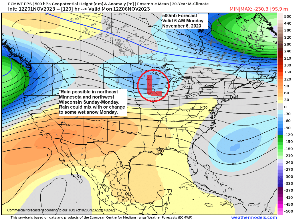
Rain chances Sunday-Monday with a little wet snow also possible; Single digit temps reported in parts of the Northland Wednesday AM with even one location dipping below zero this morning
5:28 PM Wednesday, November 1, 2023 A low-pressure system moving east out of the western High Plains this weekend could affect the Northland in the Sunday-Monday time frame. Temperatures continue to look warm enough for precipitation to mainly be in the form of rain in much of northeast Minnesota and…
-
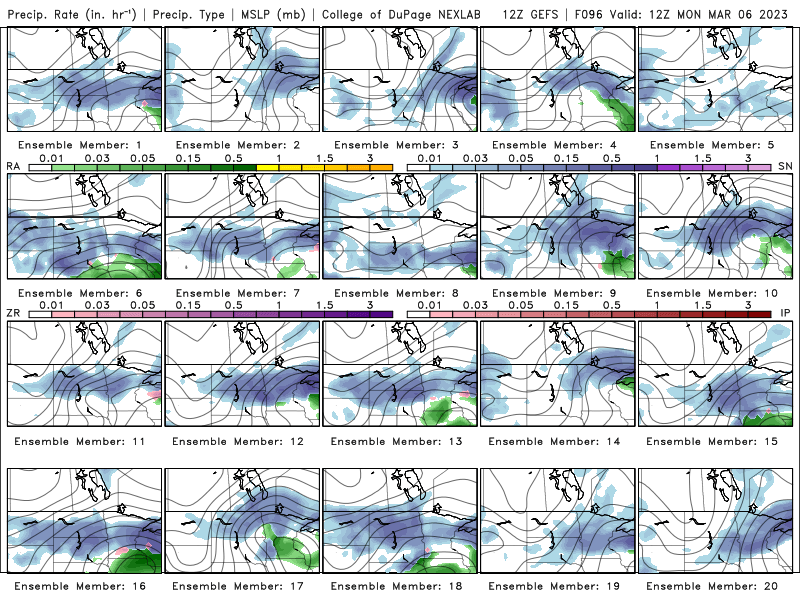
Highs in the 30s to around 40 the next few days; Chances for some snow return Sunday evening-Monday
5:08 PM Thursday, March 2, 2023 All 20 members of the GEFS model show at least some precipitation (mostly snow) impacting the Northland during the Sunday evening-Monday time frame. Here’s the GEFS model precipitation type forecast valid for 7 AM Monday, March 6, 2023. Snow (blue)Rain (green) Euro ensemble model…
-

Cold tonight with some lingering snow this evening; Highs in the 30s to around 40 Friday-Sunday; Some snow possible Sunday night-Tuesday; Snowfall Reports from today
4:54 PM Wednesday, March 1, 2023 Snowfall Reports from the March 1st Winter StormSource: National Weather Service Duluth, Minnesota 1 NE French River, MN: 12.0″Floodwood, MN: 11.0″Outing, MN: 10.5″5 WNW French River, MN: 9.5″7 WNW Pine River, MN: 8.5″French River, MN: 8.0″Federal Dam, MN: 7.5″3 NNW Lester Park, MN: 7.0″1…
-

A potentially Cold/Snowy/Active pattern next week
6:06 PM Friday, February 17, 2023 A few weak clippers could bring a few flurries and snow showers to parts of the Northland this weekend but little to no snow accumulation is expected and whatever snow does fall should mostly be over northern Minnesota with Sunday holding the best chance…
-
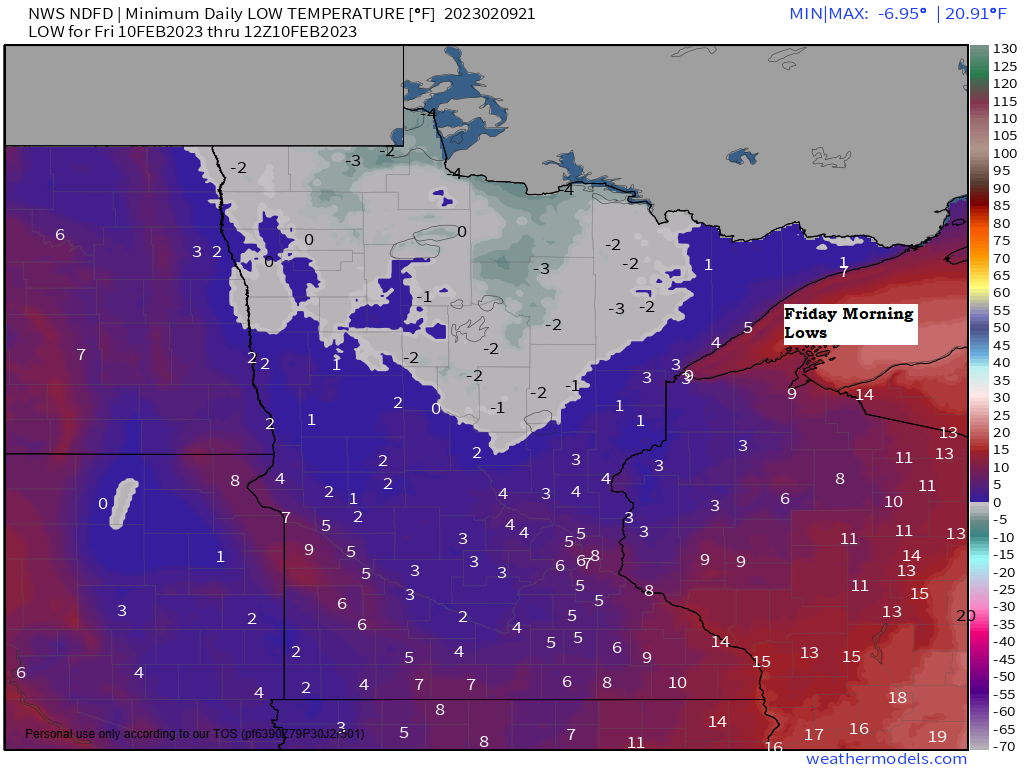
Subzero temperatures return to parts of the Northland tonight; Seasonable temps Friday followed by warmer temperatures this weekend into early next week; Snow/Rain chances increasing next Tuesday-Wednesday
5:39 PM Thursday, February 9, 2023 A brief cool down for tonight and Friday with lows tonight ranging from around 10 below to 5 above zero with highs on Friday mainly in the 20s. Highs in the 30s to low to mid 40s are likely this weekend. Note — 21…
-

Great Lakes Ice Coverage Update; Snowfall and Temperature stats for January 2023
5:58 PM Friday, January 20, 2023 The lack of any sustained cold air masses is having a major impact on ice development on the Great Lakes so far this winter, with only 3.2% ice coverage on the Great Lakes as of January 19, 2023. Looking closer at Lake Superior —…
-
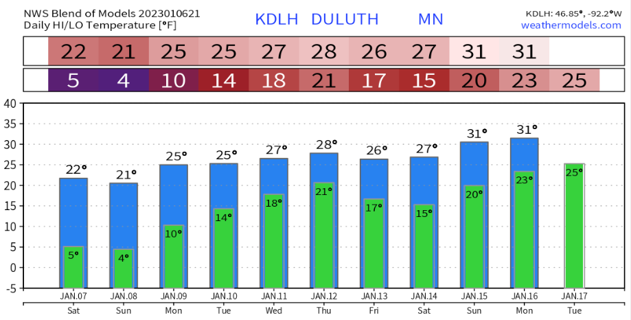
Chilly tonight with areas of low clouds/freezing fog; No signs of any sustained arctic air masses for the next 2 weeks; Snow chances return mid to late next week; Low temperature reports from Friday morning (Jan. 6)
5:48 PM Friday, January 6, 2023 The weather looks pretty tranquil across the Northland this weekend into early next week, but there could be some areas of low clouds and patchy freezing fog once again tonight through Saturday morning, and again Saturday night into Sunday morning similar to what occurred…