Tag: rain
-
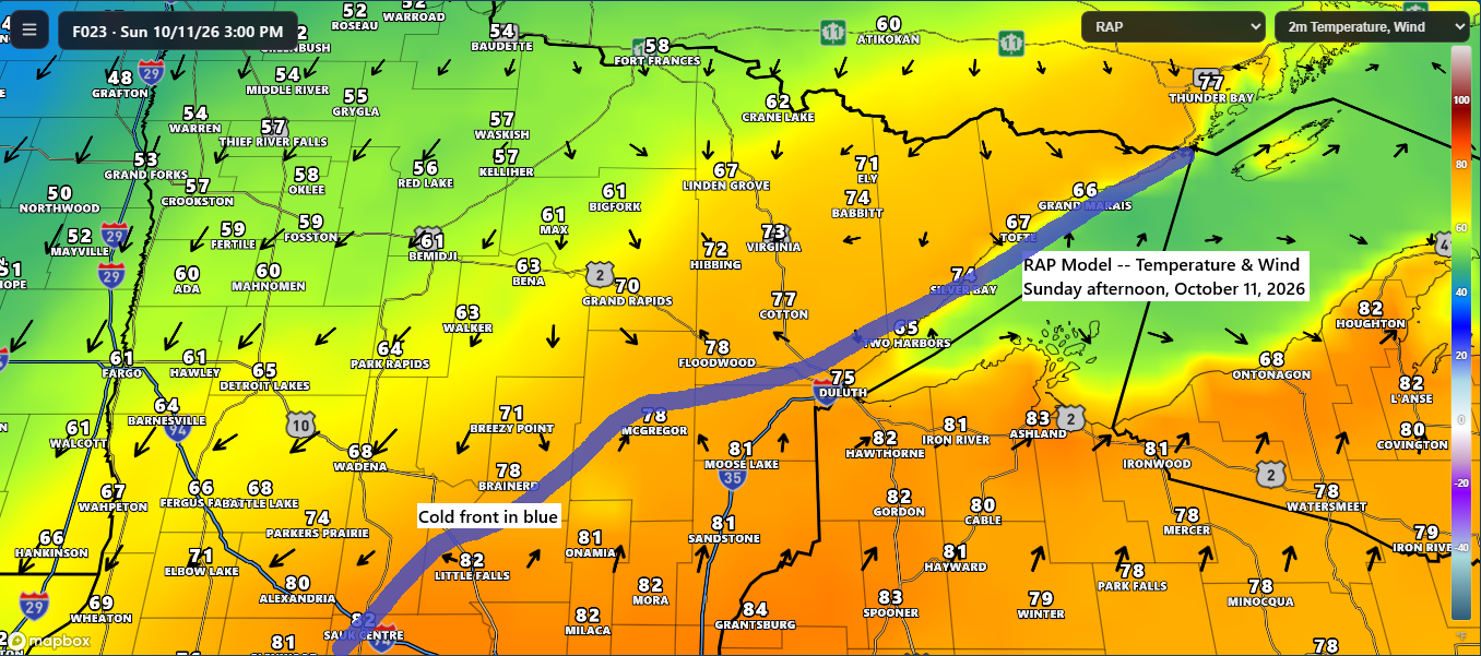
🌡️💨 Near-Record Warmth Sunday Before a Windy, Much Cooler Monday
Sunday promises another warm day with the potential for more record highs. Temperatures in northeast Minnesota and northwest Wisconsin will range from the 70s to low-to-mid 80s, while northern Minnesota will cool down behind a cold front, with highs in the 50s and 60s. Record Highs for October 11 International…
-
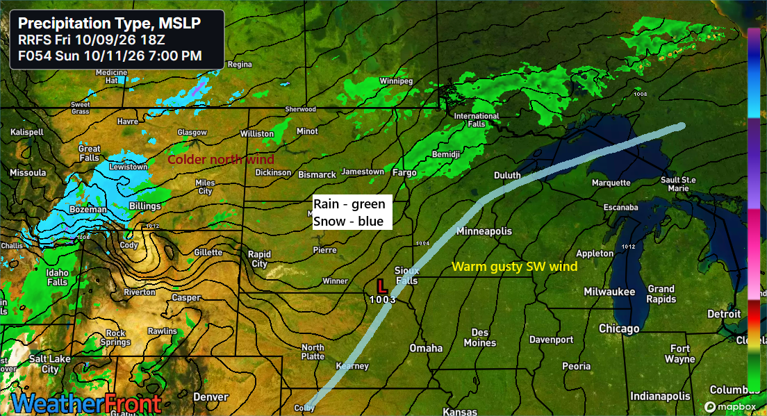
🌡️⬆️❄️🏔️Near-Record Warmth This Weekend; Snow Falls in Parts of the Rockies
Near-record warmth is expected this weekend in northeast Minnesota and northwest Wisconsin. The following are the record high temperatures that could be challenged in the coming days. October 10 Ashland, WI: 86 set in 1938Brainerd, MN: 85 set in 1928Duluth, MN: 82 set in 1938Hibbing, MN: 81 set in 1938International…
-
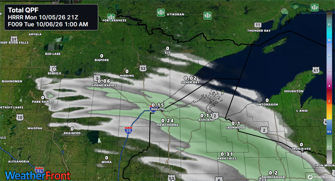
🌧️⚡🌡️Scattered Showers and an Isolated Storm Tonight; Summer-Like Warmth This Weekend
A burst of warm air and moisture, along with a southwesterly low-level jet picking up to about 30-40 knots and a warm front pushing east from western Minnesota, will bring scattered showers to parts of northeast and east-central Minnesota and northwest Wisconsin for a few hours tonight, with the best…
-
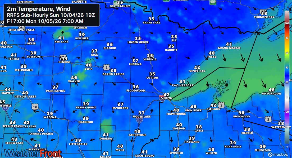
🌡️Big Changes Ahead: Freeze Alerts Now, Warm Surge Next Weekend
Freeze and frost alerts are in effect for early Monday morning across northeast Minnesota and northwest Wisconsin. Temperatures are expected to drop into the upper 20s to around 30 degrees in areas under the freeze warning, while those under the frost advisory will see lows in the low to mid-30s.…
-

🌧️➡️☀️💨Goodbye Rain, Hello Breeze: Dry Sunday Ahead
Rain in Duluth will taper off this evening by around 7 or 8 PM, leaving dry conditions overnight and into Sunday. Sunday will be breezy, with northwest winds gusting between 15 and 25 mph. On Sunday, highs in the Northland will range from the mid-50s to the low and mid-60s,…
-

🌧️⛈️Scattered Showers, Isolated Thunder Possible Saturday
A clipper-style low pressure system will travel east from southwestern Canada across the northern Plains and upper Midwest on Saturday, then move out to the east by Sunday. It’s likely to bring scattered showers to northeast Minnesota and northwest Wisconsin on Saturday, with dry weather making a return by Sunday.…
-

🌡️🌦️ Cool and Frosty Start to Friday; Scattered Showers Expected Saturday
Freeze and frost alerts have been issued for early Friday morning for nearly all of the Northland except the North Shore. In areas with a freeze warning, temperatures might dip to about 30 degrees, while regions under a frost advisory could experience lows between 32 and 34 degrees. Friday morning…