Tag: tornado
-
A warming trend near Lake Superior the next few days; Cooler (seasonable temps) inland; Scattered showers/t-storms possible Wednesday mainly in SE parts of the Northland; Heat Wave possible late this weekend-early next week
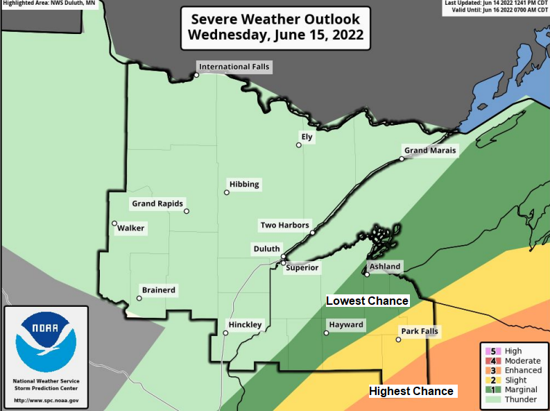
7:55 PM Tuesday, June 14, 2022 Strong to severe thunderstorms are expected Wednesday mainly from southeast Minnesota into central Wisconsin and southern upper Michigan. Storms that develop in those areas could contain large hail, damaging winds, and possibly a few tornadoes. The risk for severe weather on Wednesday is highest…
-

A brief surge of heat and humidity (away from Lake Superior) Tuesday otherwise near to slightly above normal temps this week with some showers/t-storms tonight and Monday
6:43 PM Sunday, June 12, 2022 Scattered showers and thunderstorms are possible over much of the Northland later tonight and Monday, and some of these storms could produce heavy rain with a marginal (5%) risk for flash flooding centered on southern parts of the Northland. 18z NAM 3km model simulated…
-
Frost Advisory issued for parts of northeast Minnesota
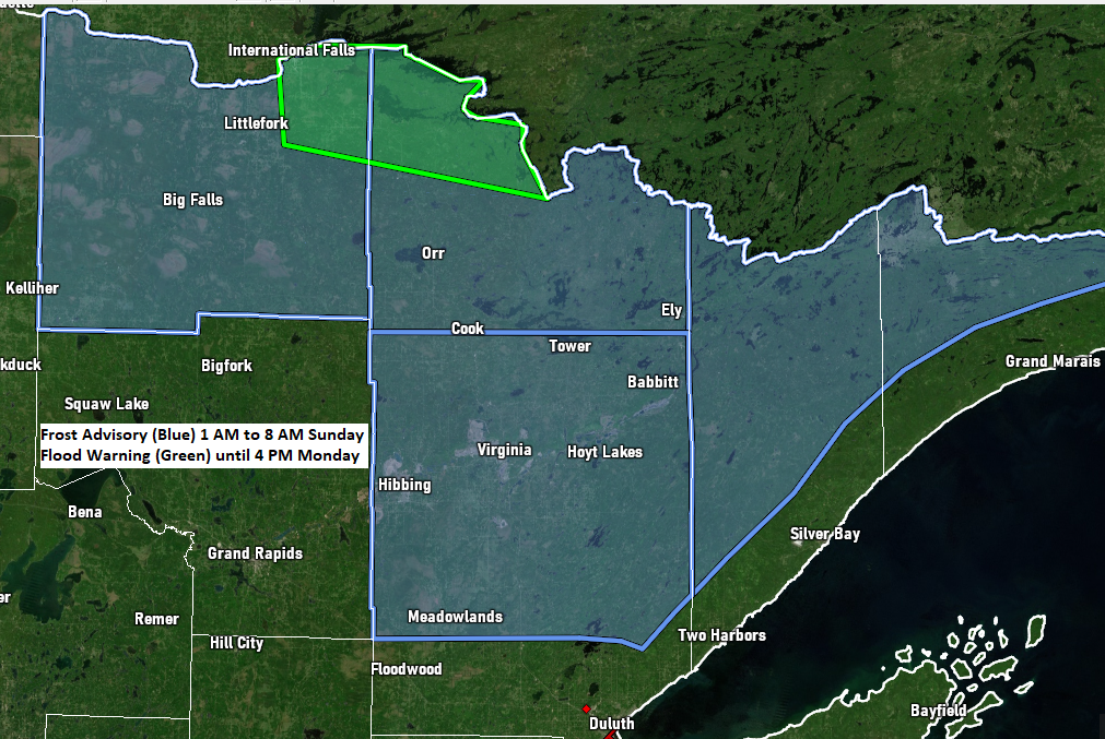
8:04 PM Saturday, June 4, 2022 A Frost Advisory is in effect from 1 AM to 8 AM Sunday for parts of northeast Minnesota including the cities of International Falls, Littlefork, Big Falls, Orr, Cook, Crane Lake, Ely, Hibbing, Virginia, Cotton, Canyon, Meadowlands, Hoyt Lakes, Wales, Isabella, and Forest Center.…
-

A cool weekend ahead with some frost possible the next few nights; NWS confirms an EF0 tornado near Rice Lake, MN on Wednesday, May 18, 2022; A mainly dry pattern setting up into late next week
5:43 PM Friday, May 20, 2022 The National Weather Service in Duluth, Minnesota has confirmed at least one tornado in the Northland with the severe thunderstorms late Wednesday afternoon, May 18, 2022. Source NWS Duluth, Minnesota 4:16 PM 5/18/2022 — 4 miles north-northeast of Rice Lake, MN (St. Louis County)…
-
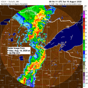
Updated – Storm Reports from around the Northland (8/14/2020)
Severe Thunderstorms producing damaging winds, flash flooding, funnel clouds and tornadoes moved through northeast Minnesota and northwest Wisconsin on Friday, August 14, 2020. Tornado – Lawler, Minnesota (Aitkin County) Date: August 14, 2020 Time: 6:57 PM – 7:02 PM CDT EF Rating: EF-1 Estimated Peak Winds: 90 mph Path Length:…
-
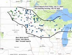
Local Storm and Rainfall Reports from Friday night-Saturday morning
Storm Reports from around the Northland from Friday night-Saturday morning, July 17-18, 2020 Source: https://www.weather.gov/ 2:51 AM 7/18: Thunderstorm Wind Gust 63 mph. 1 W Sanborn, WI (Bayfield County) 2:10 AM 7/18: Thunderstorm Wind Damage. 3 SSW Trego, WI (Washburn County) On the north side of Spooner Lake. One boat…
-
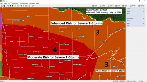
Severe Thunderstorms likely late tonight with widespread wind gusts >70 mph, isolated tornadoes and large hail also possible
A significant severe weather threat exists late tonight into early Saturday morning over much of the Northland with scattered to widespread severe thunderstorms possibly producing significant damage. There is a Moderate Risk and Enhanced Risk for Severe Thunderstorms in place across the entire Northland for tonight. Note: A moderate risk…