Tag: hail
-
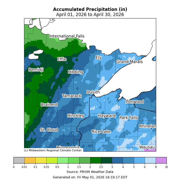
April 2026: Precipitation and Temperature Anomalies in the Northland
In April 2026, persistent troughing dominated the western U.S., while ridging stretched from the southern to eastern regions. This setup brought an active southwest upper-level flow and a busy weather pattern to the Northland, with cooler-than-average temperatures in northern Minnesota and warmer-than-average conditions in parts of northwest Wisconsin. Average temperatures…
-
Rain Fades Tonight; Frosty Nights on the Way
Much of the Northland has seen a rainy Monday, thanks to a strong low-pressure system lingering over far southeast Minnesota late this afternoon. The system will move northeast, eventually passing north of Lake Superior by Tuesday. Widespread rain will persist in the Northland northwest of the low tonight, but it’s…
-
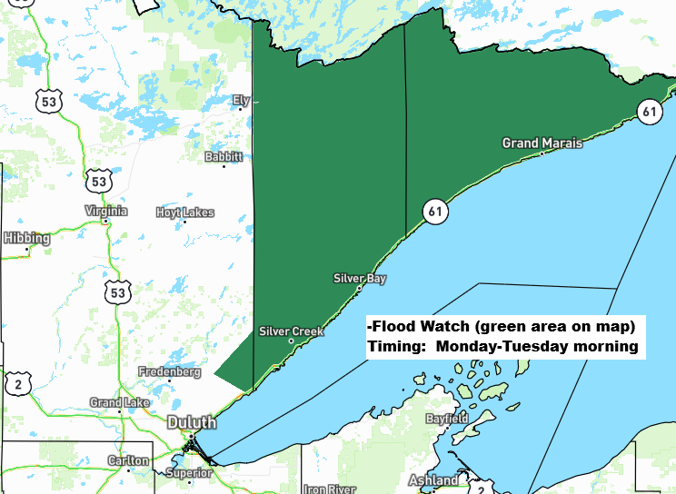
Rainy, Breezy Monday; Flood Watch North Shore
Widespread rain totals of about a half inch to an inch or more are expected in northeast Minnesota and northwest Wisconsin by late Monday night. This rain on already saturated soils in the Arrowhead of Minnesota and along the North Shore of Lake Superior may lead to excessive runoff and…
-
Summerlike 80s/90s in MN Today, Turning Showery Thursday
Tonight, a warm front will lift north out of southern Minnesota but this front will likely grind to a halt once it reaches the Northland, and that front will then be overtaken by a cold front which tracks eastward out of western Minnesota on Thursday. A few showers or thunderstorms…
-

Storm Reports: Friday April 17, 2026
A busy Friday of severe weather, spanning from the upper Midwest to the central Plains, as a strong cold front pushes southeast through the region. Strong wind shear, fast upper-level winds, significant instability, and warm, humid air have all combined to trigger an outbreak of severe thunderstorms this afternoon. In…
-
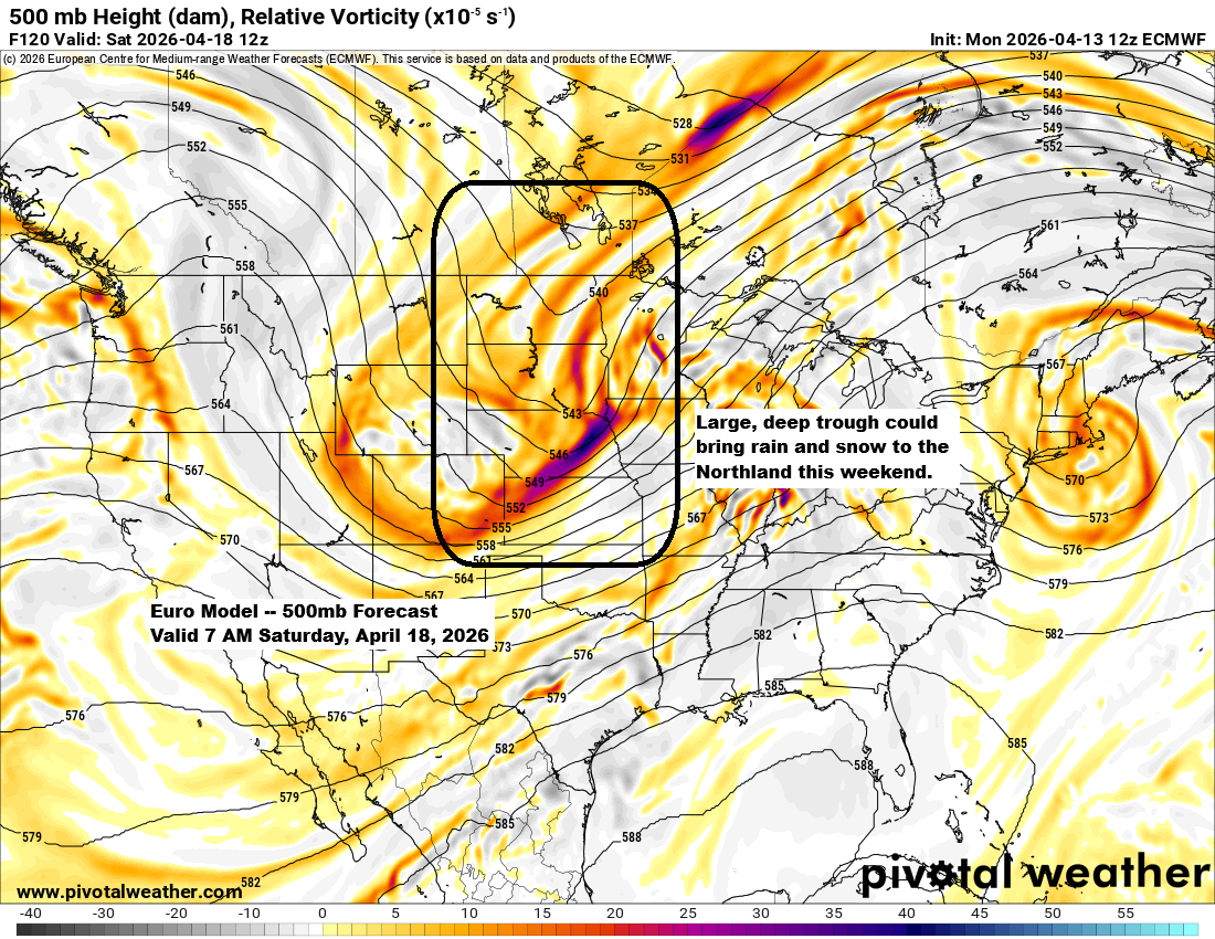
Mild inland, cooler by the lake with fog at times; late‑week and weekend precipitation possible
Later this week into the weekend, a large and possibly deep trough could move over the upper Midwest and western Great Lakes. At first, the Northland will be on the warmer side, east of the trough, with some rain possible Friday and Friday night. By Saturday, much colder air is…
-
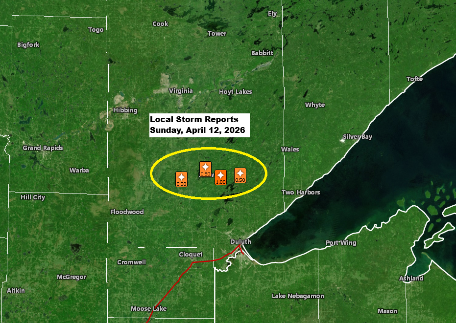
Local storm, rainfall, and temperature reports.
Late this afternoon, a single strong thunderstorm popped up near the warm front stretched across northeast Minnesota. This cell first appeared around 4:30 PM today near Hill City, Minnesota, before moving east-northeast. The storm hit peak intensity between about 6:00 and 6:45 PM, with cloud tops reaching around 40,000 feet…